Explore
Featured
Recent
Articles
Topics
Login
Upload
Featured
Recent
Articles
Topics
Login
Upload
Search Results for 'data satellites'
data satellites published presentations and documents on DocSlides.
SATELLITES What They Do and
by alexa-scheidler
How They Work. Michael J. Mackowski. Aerospace En...
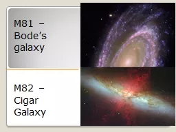
M81 – Bode’s galaxy
by karlyn-bohler
M82 – Cigar Galaxy. ASTR 2401. Goal. Target sel...
Global Positioning System: An Introduction
by myesha-ticknor
David Treharne, n8hku. Ford amateur radio league,...
By- jay patel (130110105027)
by dandy
aakash. . patel. (130110105001). urvish. . soni...
3.3.3
by kittie-lecroy
Satellite Communications Systems. RECAP. How many...
Space spinoffs and exploration
by tawny-fly
J. Blake 2014. Space Exploration . Space shuttles...
21 Sept. 2017 Presented By:
by phoebe-click
Jon Christopherson. SGT, Inc. . Contractor to the...
Challenges of Forecasting in the Fairbanks Area of Responsi
by celsa-spraggs
Melissa . Kreller. , NWS Fairbanks. Eric Stevens,...
Collecting Geographic Coordinates
by karlyn-bohler
Using GPS Devices. <date of training> ....
Identifying
by tawny-fly
NaK. Objects. in Space Debris. Johanne Christens...
Design Develo pment of FPGA based Digital Demodulator As d ifferent Satellites use different modulation schemes with variable data rates i n order to cater to the Multi satellite data reception req
by tawny-fly
The demodulation techniques for Binary Quadratur...
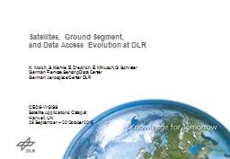
Satellites, Ground Segment,
by tatyana-admore
and . Data Access . Evolution at DLR. K. Molch, S...
Committee on Earth Observation Satellites
by phoebe-click
Stephen Briggs & . SDCG . EXEC . (. Ake. . R...
1 User Services and Support for NESDIS Satellite Products a
by marina-yarberry
Matthew Seybold, User Services Coordinator. Natal...
Committee on Earth Observation Satellites
by trish-goza
Plenary . Agenda . Item . #. 3. 29. th. CEOS Ple...
Introduction to Remote Sensing of the Environment
by alida-meadow
Bot/. Geog. 4111/5111. Ken Driese. Dept. of Bota...
1 User Services and Support for NESDIS Satellite Products and Services
by everfashion
Matthew Seybold, User Services Coordinator. Natali...
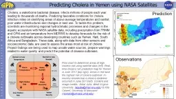
Predicting Cholera in Yemen using NASA Satellites
by pagi
Cholera, a waterborne bacterial disease, infects m...
Disease Initiative Global Precipitation Measurement Mission
by anya
Case Studies developed for the GPM Disease Initiat...
Network and internet Basics
by skylar
Lecture9. Computer skills2. 2018-2019. Identify co...
GPS Fundamentals and Field Mapping
by sherrill-nordquist
. University of Rhode Island. January 26. , 2016...
Predicting Cholera in Yemen using NASA Satellites
by tawny-fly
Predicting Cholera in Yemen using NASA Satellites ...
Survey of Dark EnergyDePies Precision data from satellites and other m
by conchita-marotz
.1)1()(22222222 cdxdxgdsdrkrdrtSdtdsr)()(tSt HSSH ...
EUMETSAT
by min-jolicoeur
. Satellite Application Facility on Support to O...
Geodesy
by stefany-barnette
A look at the Earth. What is Geodesy?. - The Merr...
Essential Questions What are some of the different types of remote sensing?
by pasty-toler
How are satellites and sonar used to map Earth’...
Navigation Systems and Their Implementation
by stefany-barnette
Michael Bekkala. Michael Blair. Michael Carpenter...
Obtaining the User’s Position
by cheryl-pisano
Dr. Miguel A. Labrador. Department of Computer Sc...
GPS Basics An introduction to GPS technology
by ellena-manuel
Acknowledgements . Thank you to the University of...
NOTICE: The information contained within this document is copyright
by sherrill-nordquist
© U.S. Coast Guard . Auxiliary Association. No a...
Overview of GPS Overview of how time is obtained from GPS
by tatyana-admore
One-Way time transfer. - Uncertainty analysis of ...
Dual Mode Connectivity for M2M
by tatiana-dople
Bill . Molesworth. Vice President, Terrestrial Wi...
WELCOME Mobile Applications Testing
by marina-yarberry
1. Copyright NataliaS@portnov.com. Mobile Applica...
Scott Gudes Vice President, Legislative Affairs
by ellena-manuel
Scott Gudes Vice President, Legislative Affairs S...
Futuristic view of C4I systems in civil and
by alida-meadow
Futuristic view of C4I systems in civil and de...
Internet-of-Things ( IoT
by startse
). Summer Engineering Program 2018. University of ...
KARI’s Satellites &
by eatsyouc
. ARD. Chiho. KANG & . Daehoon. YOO, KARI. C...
Prof V N R PillaiFormer ViceChancellorFormer ProViceChancellorPr
by cecilia
Block Preparation TeamDr. Debashish ChakravartyDr....
What is GPS? How does GPS work?
by jocelyn
What is the uncertainty of GPS positioning?. What ...
Load More...